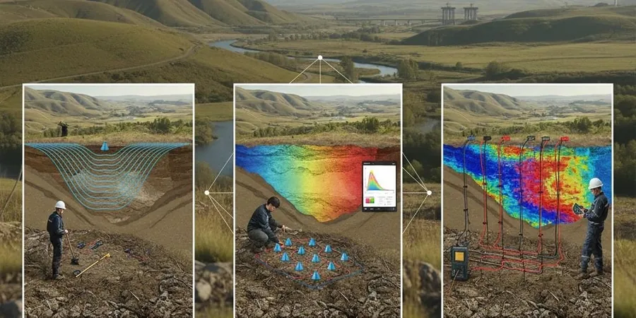
The subsurface contrast between the Alta Loma bench and the Terra Vista area in Rancho Cucamonga tells a story that surface mapping cannot. Up on the alluvial fan slopes north of Banyan Street, coarse bouldery deposits from Cucamonga Canyon sit over shallow granitic bedrock, while down south toward the 210 Freeway you encounter finer basin-fill sediments hundreds of feet thick before reaching competent material. Seismic tomography gives us the velocity cross-section to map these transitions without drilling a single borehole on the front end. We run both P-wave and S-wave spreads with 24- or 48-channel geophone arrays, then invert traveltimes to build 2D profiles that show where rippable material ends and refusal begins. For geotechnical engineers working on Rancho Cucamonga sites, pairing seismic tomography with targeted SPT drilling lets you calibrate velocity boundaries against actual blow counts, while a MASW survey refines the Vs30 value the building department requires under ASCE 7-16 Chapter 20.
A velocity boundary at 1,200 m/s in the tomogram often marks the transition from dry alluvium to saturated gravel in the Cucamonga basin; missing that layer changes liquefaction settlement calculations entirely.
Scope of work
Area-specific notes
The most common mistake we see on Rancho Cucamonga jobsites is relying solely on shallow test pits to characterize a site that sits on buried channel deposits. Cucamonga Creek and Deer Creek have shifted course repeatedly over the Holocene, leaving paleochannels filled with loose sand and gravel lenses that a 4-foot deep excavation simply misses. Seismic tomography exposes these features because the low-velocity sand bodies show up as distinct anomalies surrounded by stiffer alluvial matrix. Another frequent issue arises when contractors assume uniform bedrock depth across a parcel that straddles the contact between the alluvial fan and the older San Antonio Heights formation. A tomographic line run along the proposed building pad reveals the bedrock surface dipping 15 degrees or more, which changes foundation design from shallow footings on one half of the structure to deep foundations on the other. In the 2008 Chino Hills earthquake sequence, sites with poorly characterized velocity contrasts experienced differential settlement that cost developers months of litigation. The tomographic data set, when combined with laboratory index testing on borehole samples, gives the geotechnical engineer a defensible ground model that holds up under plan-check scrutiny from the City of Rancho Cucamonga Building and Safety Division.
Standards used
ASTM D5777-18 (Standard Guide for Using the Seismic Refraction Method), ASTM D7128-18 (Standard Guide for Using the Seismic Reflection Method), ASCE 7-16 Chapter 20 (Site Classification Procedure for Seismic Design), IBC 2021 Section 1613 (Earthquake Loads and Site Class Determination), Caltrans Geotechnical Manual Chapter 6 (Geophysical Investigations)
Linked services
Refraction Microtremor and MASW for Vs30 Compliance
Active-source and passive-source surface wave surveys processed through dispersion curve inversion to deliver site class determination per ASCE 7. We handle the full submittal package for Rancho Cucamonga building permits, including the Vs30 calculation, site class letter, and raw dispersion data.
2D Seismic Refraction Tomography for Bedrock and Groundwater Mapping
Multi-shot refraction spreads processed with wavepath eikonal tomography to produce continuous velocity cross-sections. Used extensively on hillside lots in the Alta Loma and Etiwanda areas where granitic bedrock depth controls foundation cost and retaining wall design.
Typical parameters
Common questions
How much does a seismic tomography survey cost for a typical Rancho Cucamonga residential lot?
For a standard 7,000 to 10,000 square foot residential parcel, a combined refraction and MASW survey with full Vs30 reporting typically ranges from US$2,490 to US$6,030 depending on the number of spread lines, target depth, and whether passive-source recording is required to meet the 30-meter depth threshold for site class determination.
Does the City of Rancho Cucamonga accept seismic tomography in lieu of boreholes for site classification?
The City accepts geophysical Vs30 determination per ASCE 7-16 when supported by adequate measurement of shear wave velocity to at least 30 meters depth. However, most projects still require at least one exploratory boring or test pit for soil sample recovery and laboratory strength testing. Seismic tomography complements the boring program and often reduces the total number of boreholes needed.
What kind of seismic sources do you use and will they disturb neighboring properties?
We use a 20-pound sledgehammer and a 100-pound accelerated weight drop for most Rancho Cucamonga sites. The weight drop is mounted on rubber tracks and produces a thud comparable to a vehicle door closing. On tight lots near existing homes we can switch to a Betsy seisgun with reduced charge. We notify adjacent property owners 48 hours in advance and record vibration levels with a seismograph to demonstrate compliance with the City vibration ordinance.
How long does a seismic tomography survey take and when do we receive the final report?
Field acquisition for a single refraction line of 115 meters takes one half-day with a two-person crew. Multi-line sites with MASW passive arrays require one to two full field days. The tomographic inversion, interpretation, and report drafting are completed within seven to ten business days. Expedited three-day turnaround is available when foundation design decisions are pending.